2D Moving Map
![]() Bill Gates experiences my work first hand.
Bill Gates experiences my work first hand.
Skills
Adobe Flash, including ActionScript and web services

Summary
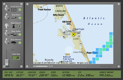
This application is a front end consumer of the Assured Aviation Web Services (AAWS) project of DSI, in partnership with NASA’s Small Aircraft Transportation System (SATS) program.
The 2D Moving Map connects to an in-house web service to retrieve GPS coordinates and a series of JPG images to illustrate real-time air traffic at five-second intervals. Virtual switches on this cockpit panel toggle overlays for weather, aircraft, airports, and the like. A zooming slider resizes the map, and the map’s scale becomes an interactive measuring tool to estimate distances between objects. An “LCD screen” along the bottom updates to display altitude, latitude, longitude, air speed, and more.
